Redlands Lane was a rural track through fields from Blackbrook Turnpike, past a couple of cottages and the brick fields near Solent Cottage, down to Cams Alders. Despite it being busy, it is only designated U491 - the same as all of the streets branching off it.
The 1898 map shows the start of Paxton Road with houses spread out along it. Redlands and Oakcroft were the two main properties opposite Blackbrook Lodge, which became Blackbrook Grove. Alders Farm and Minden Cottage are shown for the first time. Oakcroft later became Croft House, and is now used by the council.
Development is slow until the 1951 map. Suddenly, Avenue Road is developed and Paxton Road stretches to The Gillies; Chamberlain Grove has been built; and the West End estate is stretching out in a strange shape filling a long line of fields.
The Redlands Inn (demolished 2005) and builders yard are shown, and Wallisdean County Infants School is there at the very edge of the housing surrounded by fields. By 1961, Paxton Road had been extended across The Gillies - you can still see the old turning circle. At the time it was possible to both drive up Paxton Road and turn right at the end - this was changed in the 1990s. Four properties at the north of Paxton Road were demolished when The Avenue was widened.
By the 1971 map, the developed area now stretches as far as Bishopsfield Road and beyond. St Ann's County Infant School (later Neville Lovett and then Fareham Academy), and Longfield Avenue is now much longer.
The Admiral Cunningham was at the corner of Bishopsfield Road and Longfield Avenue. It was demolished for flats in 2012, having closed shortly before.
The builder's yard has become St John's Church and Hall, and the farm and 'Redlands' have become apartment blocks and garages. A couple of years later the Cams Alders sports ground is shown.
The Eastern End
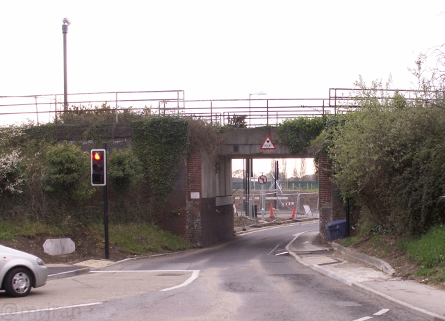
The narrow railway bridge gives us a good idea what the road would have been like originally.
Priority was given to Windmill Lane, at least after the railway was built. This became Mill Road by the end of the 19th century, its windmill having closed. Instead it served a brick field and a series of terraces for its staff. The site of the mill became Briarwood, and the brickworks had gone by the 1920s. The mission room moved further down the road.
There was a football ground to the south of the road, but by the 1950s the whole area had been filled in for housing and the boat-building yard. The brickworks became allotment gardens and then became Combe Farm Avenue.
In the 1960s, some houses were knocked down to allow Holbrook Road to be built. This opened up playing fields, although they were later reduced in size. The Depository was built and then knocked down to create Eden Rise.
The main Redlands Lane had a similar story. It was an empty lane with Shamblers Farm at the end. The school appears in the 1920s and was soon extended.
Fayre Road was built in the 1940s and numbers 174 to 180 Redlands Lane were added a few years later. The five apartment blocks were added in the 1950s.
At the end of the road, Cams Alders farm continued to grow, until it became the depot for Tom Parkers Dairies.